Southeast Asia’s sole landlocked country and independent republic, Laos is located west of Vietnam and northeast of Thailand. It occupies a region of 236,800 square kilometers in the middle of Southeast Asia’s peninsula and is bordered by Thailand, Vietnam, the People’s Republic of China, Myanmar (Burma), Cambodia, and the People’s Republic of China. Mountains, mountains, plateaux, and rivers cut through around 70% of its total area.
Due to its geographic position, it has frequently served as a commercial and communication hub as well as a buffer state between more powerful bordering states. Laos has served as a strategic trade location and its geography has accommodated the growing commerce.
With its forested highlands, upland plateaus, and lowland plains, Laos’ geologically diverse geography supports an equally diversified people that are mostly brought together through agriculture, particularly the growing of rice.
Between the 5th and the middle of the 19th century, interactions with the neighboring Khmer (Cambodian), Siamese (Thai), and Myanmar (Burmese) kingdoms resulted in both hostile and friendly cultural influences on Laos, notably Buddhism, which is currently practiced by the majority of the population in Laos.
Despite being largely unknown to tourists, backpackers, and travelers for many years, this interesting country is starting to show up on many bucket lists due to its largely natural beauty, vibrant culture, and unique history and traditions. Laos is also home to wonderful geography. It undeniably caters to beautiful mountains and steep forested hills that cover over three-quarters of its entire landmass.
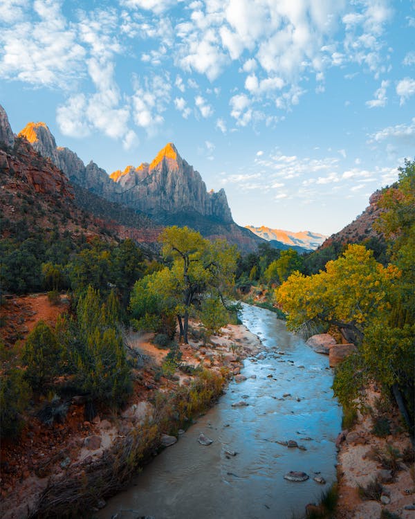
The Mekong River is essential as a conduit for shipping goods and people, a source of energy at dams, a source of water for farming, and a habitat for fish, which form a significant part of the Laotian diet. The Xiangkhiang, Khammouan, and Bolovens Plateaus are the three plateaus that lie between the mountains and the Mekong River.
The Dong Falls in the southern end of the country prevent access to the sea, although cargo boats travel along the entire length of the Mekong in Laos for most of the year. Smaller power boats and pirogues serve as an important mode of transportation on many of the Mekong’s tributaries.
The Mekong has thus not been a barrier to communication but a facilitator, and the cultural similarities between northeast Thai society and Lao society reflect the close contact that has existed across the river for centuries. Additionally, many Laotians living in the Mekong Valley have friends and family in Thailand which displays how incredible the relationship had been between these people with a shared culture.
Meanwhile, the Annamite Range in the northeast and east and the Luang Prabang Range in the northwest are two mountain ranges that are characteristically known for their steep terrain. Laos’ topography is predominantly mountainous. Elevations are normally above 500 meters, and there are few river valleys and few possibilities for agriculture. With the exception of Vientiane’s plain and the Plain of Jars on the Xiangkhoang Plateau, the majority of the north of the country is covered by this rugged terrain.
The Bolovens Plateau, which is close to Cambodia, offers more lush farmland where coffee, tea, rice, strawberries, and pineapples are farmed. The Xiangkhiang is the largest. For the Lao people, the lowlands are most important. There, the Mekong River inundates the soil, supplying it with enough nutrients to enable the cultivation of enough rice and other crops to feed the entire nation for a year.
The majority of the population resides along the river, which travels through Laos and south Vietnam for a distance of more than 2,600 miles (4,180 kilometers). Only 10% of the nation lies below 600 feet, and Phu Bia, the highest peak, is 9,242 feet high (2,817 meters).
Between Vietnam’s Chinese-influenced culture and the Indianized states of Laos and Thailand, the eastern border with Vietnam stretches for 2,130 kilometers, mostly along the crest of the Annamite Chain. These mountains are sparsely populated by tribal minorities who traditionally have not acknowledged the border with Vietnam, much like lowland Lao have been constrained by the 1,754-kilometer Mekong River border with Thailand.
As a result, there are ethnic minority populations on both the Laotian and Vietnamese sides of the border. Contact between these communities and lowland Lao has primarily been limited to trading due to their relative isolation.
Laos’ harsh, forested mountains, which reach a maximum elevation of 9,245 feet (2,818 meters) above sea level at Mount Bia in the north and are a major obstacle to travel everywhere, dominate the country’s terrain. There are numerous minor ranges, but the main range is located along a northwest-southeast axis and is a section of the Annamese Cordillera (Chaîne Annamitique). The Plain of Jars, also known as Thông Haihin, is a communications hub located on the Xiangkhoang Plateau in north-central Laos. Its name comes from the vast prehistoric stone jars that were discovered there.
There are caverns and severely degraded limestone pinnacles in the karst terrain of the central provinces of Bolikhamxay and Khammouan. At an elevation of roughly 3,600 feet (1,100 meters) in the south, the Bolovens Plateau is covered in open woods and has typically fertile soil. Only a small portion of the Mekong River’s eastern bank is covered in large lowlands.
The alluvium that is deposited by rivers to create the floodplains’ soils is either sandy or sandy clay with light colors or sandy with gray or yellow colors; chemically, these soils range from neutral to slightly acidic. In general, crystalline, granitic, schistose, or sandstone parent rock-derived upland soils are more acidic and significantly less fertile. Both basaltic soils on the Bolovens Plateau and laterite (leached and iron-bearing) soils can be found in southern Laos.
In the north of Laos, there are tropical rainforests with broad-leaved evergreens, and in the south, there are monsoon forests with mixed evergreen and deciduous species. The ground is covered in a long, coarse grass called tranh in the monsoon forest regions, and there is a lot of bamboo, brush, and wild bananas. The trees are primarily secondary growth. A huge variety of palm and orchid species can be found in Laos.
Laos is also home to beautiful biodiversity. Nearly 200 kinds of animals, almost the same number of reptiles and amphibians, and about 700 different bird species live in the forests and grasslands. Deer, bears, monkeys, and gaurs (wild oxen) are examples of common mammals. Several species of wild oxen, monkeys, gibbons, elephants, rhinoceroses, and tigers are among the country’s endangered mammals. So if you are a traveler and you want to view this wildlife, Laos is also a great country to visit to witness the incredible biodiversity.