Roughly 6.5 million people are living in the Republic of Laos, who are frequently categorized into lowland, Midland, and upland Laotians based on elevation.
The Lao, who make up the majority of the population and reside primarily in the lowlands, are the largest ethnic group. The Khmou, at 11%, the Hmong, at 8%, and more than 100 other ethnic groups that together make up the so-called highland or mountain tribes, which make up around 20% of the population, are other significant ethnic groupings. Vietnamese people of ethnicity make up another 2%.
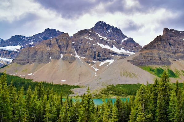
Laos covers 236,800 square kilometers in total (91,429 square miles). The only landlocked nation in Southeast Asia is this one.
To the southwest is Thailand, to the north is Myanmar (Burma), to the northwest is China, to the south is Cambodia, and to the east is Vietnam. The Mekong River, which serves as the region’s main thoroughfare, serves as its current western border.
The Plain of Jars and the Plain of Vientiane are Laos’ two main plains. The rest of the nation is mountainous, with only 4% of it being arable. Phou Bia, at 2,819 meters, is the highest point in Laos (9,249 feet). The Mekong River, at 70 meters, is at its lowest point (230 feet).
Laos has a tropical monsoonal climate. There is a dry season from November to April and a wet season from May to November. An average of 1714 mm (67.5 inches) of precipitation falls during the rainy season. 26.5 C is the average temperature (80 F). In April, the average temperature is 34 C (93 F), while in January, it is 17 C (63 F).
Laos has a very warm climate, with an average annual temperature of 32 degrees, but few really tropical and humid months. It is warm or hot all year long. Champasak is the country’s warmest and wettest region. The most subzero is Xiagnabouli. The greatest time to travel is between November and March because of the lower rainfall. From May to September, most precipitation decreases.
Regional variations in rainfall have been observed, with the Bolovens Plateau in Champasak Province recording the greatest totals (3,700 millimeters; 150 inches) annually. According to city rainfall stations, Vientiane receives about 1,700 millimeters (67 inches) of rain yearly, while Louangphrabang (Luang Prabang) receives about 1,360 millimeters. Savannakhét receives an average of 1,440 millimeters (57 inches) of rain annually (54 inches).
The comparatively high average precipitation hides years where rainfall may be only half or less of the usual, leading to severe decreases in rice yields. Rainfall is not always sufficient for rice farming. These droughts are frequently localized, meaning that production in other areas of the nation is unaffected.
The average temperatures in January, the coolest month, are 20.5 °C in Luang Prabang, 20.3 °C in Vientiane, and 23.9 °C in Pakse; in April, the hottest month, the average temperatures are 28.1 °C in Luang Prabang and 39.4 °C in Vientiane. Altitude does affect temperature; on average, there is a 1.7°C decline in temperature for every 1000 feet of elevation (or 300 meters). The highland plateau and the mountains are thought to have cooler temperatures than the plains near Vientiane. Nearly all of Laos’ provinces are at high risk from climate change, making the country extremely vulnerable to its impacts.
The wet season is already fully underway in July in Laos, and average daily temperatures are still above 30°C. Temperature drops are common, with southern regions seeing cooler weather (specifically the Bolaven Plateau). In the south of Laos, cascading waterfalls may once again be seen, while in the center of the country, rich green foliage starts to cover the landscape as it gets wetter.
But if you are planning on visiting Laos in September, all around the nation, rainfall is currently at its highest point, and it might still be challenging to drive to isolated locations. However, as the month draws to a close, the sun will begin to show up, which along with the waterfalls and lush surroundings makes this one of the most alluring periods to travel for anyone seeking breathtaking natural scenery.
At the Boun Khao Padabdin/Rice and Boat Racing Festival, which takes place in September, villagers donate food to monks and departed loved ones as a way of honoring the dead. Then, in honor of water deities and the Nagas, hand-built boats raced down the Mekong River.
The greatest time to visit Laos is from October to April when the climate is mild and dry all year long. The greatest time to go by the river is between November and January, when the Mekong River, Laos’ principal waterway, has high water levels that make transit simple. At this time of year, going to the Bolaven Plateau is also enjoyable.
Laos’ terrain has a significant impact on its climate, and the highlands, which are primarily in the country’s northern, eastern, and central regions, nevertheless experience chilly temperatures. Between late May and October, when the country’s rains resume, is known as the “green season.” Showers, on the other hand, are typically brief and abrupt, barely affecting your exploration. The country comes to life at this time of year, with waterfalls starting.
The return of dry weather and shoulder season discounts make October a fantastic month to visit Laos as well. Additionally, it offers ideal circumstances for river travel. The milder months of December and January are preferable for trekking.
Every November, the country is generally experiencing dry weather, and this is the busiest time of year to travel by river when water levels are at their highest. Around the mid to high 20°C range, temperatures will be comfortable, and there is a wide variety of flora and wildlife. So if you are planning to visit the country in November, you will also get to witness tens of thousands of monks and pilgrims congregate at the That Luang or Grand Stupa, a significant icon of Laos, during the three-day religious celebration that takes place in November in Vientiane. They carry wax candles.